


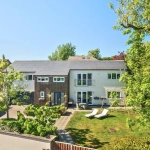
Overview
- Building
- 1
- 1
- 1
- 100 sqft
- 2020
Description
Lorem Ipsum is simply dummy text of the printing and typesetting industry. Lorem Ipsum has been the industry’s standard dummy text ever since the 1500s, when an unknown printer took a galley of type and scrambled it to make a type specimen book. It has survived not only five centuries, but also the leap into electronic typesetting, remaining essentially unchanged. It was popularised in the 1960s with the release of Letraset sheets containing Lorem Ipsum passages, and more recently with desktop publishing software like Aldus PageMaker including versions of Lorem Ipsum.
Property Documents
Crime Rates
Neighbourhood Team
Neighbourhood Team Address
Loading Name Data...
Loading Address Data...
Loading Postcode Data...
Force Website:
Data courtesy of police.uk. See our Data Sources page for more information.
Continue Reading: All About Nearby ServicesAn analysis of local crime statistics is a necessary step in property acquisition, directly influencing safety, insurance premiums, and long-term property valuation.
Average Crime
Loading Data... reported crimes
In this area in the last 12 months.
If an area has an average crime rating, it means that for every 1,000 inhabitants, between 140 and 225 residents have been affected by a crime.
This might suggest that an area may be more developed and suburban rather than rural, with a higher population of residents.
The most common reported crimes are:
Loading Category Data...
Loading Total Data...
Loading data...
Housing Types
Loading data..
Loading data..
Housing Tenure
Loading data...
Loading data...
Housing Occupancy
Loading data...
Loading data...
Household Composition
Loading data...
Loading data...
Household Deprivation
Loading data...
Loading data...
Gender
Loading data...
Loading data...
Age Groups
Loading data...
Loading data...
Relationship Status
Loading data...
Loading data...
Health
Loading data...
Loading data...
Highest Qualification Level Achieved
Loading data...
Loading data...
Ethnic Group
Loading data...
Loading data...
Country of Birth
Loading data...
Loading data...
Length of Residence
Loading data...
Loading data...
Passport(s) Held
Loading data...
Loading data...
Religion
Loading data...
Loading data...
Economic Activity
Loading data...
Loading data...
Occupation Group
Loading data...
Loading data...
Socio-Economic Classification
Loading data...
Loading data...
Address
Open on Google Maps-
Address: Roseland Crescent, Stoke-on-Trent ST2 7BQ, UK
-
City: Stoke-on-Trent
-
County: England
-
Post Code: ST2 7BQ
Details
Updated on June 4, 2025 at 4:15 pm-
Property ID 46906
-
Price 1000 £1,000
-
Property Size 100 sqft
-
Land Area 100 sqft
-
Bedroom 1
-
Bathroom 1
-
Garage 1
-
Garage Size 100
-
Year Built 2020
-
Property Type Building
-
Property Status For Rent
Video
Energy Class
-
Energetic class: A
- A+
- | Energy class AA
- B
- C
- D
- E
- F
- G
- H
")
